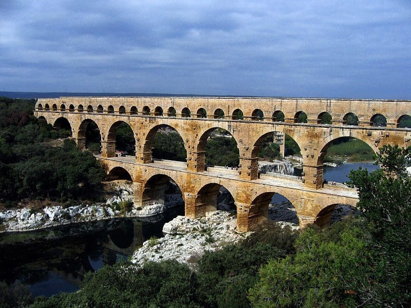
I am Pont du Gard

by | Mar 2, 2013 | France

I am Pont du Gard – a Roman aqueduct bridge (Bridge of the Gard River)

I am part of the Nîmes aqueduct, a 50 km-long structure built by the Romans to carry water from a spring at Uzès to the Roman colony of Nemausus (Nîmes).  Because the terrain between the two points is hilly, the aqueduct – built mostly underground – took a long, winding route that crossed the gorge of the Gardon, and needed construction of an aqueduct bridge.  Built in the 1st century AD, the Pont du Gard is the highest of all Roman aqueduct bridges and is the best preserved after the Aqueduct of Segovia.  It was added to UNESCO’s list of World Heritage Sites in 1985 because of its historical importance.

Pont du Gard

Pont du Gard

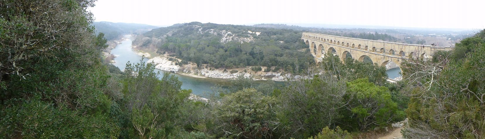
The bridge has three tiers of arches, standing 48.8 m high.  The whole aqueduct descends in height by only 17 m over its entire 50 km length, and the bridge itself descends a mere 2.5 cm over its 274 m length – a gradient of only 1 in 3,000 – which indicates the great precision that Roman engineers were able to achieve.  The aqueduct carried about 200,000 m3 of water a day to the fountains, baths and homes of the citizens of Nîmes.  It continued to be used possibly until the 6th century, with some parts used for significantly longer, but lack of maintenance after the 4th century meant that it became increasingly clogged by mineral deposits and debris that eventually choked off the flow of water.

After the collapse of the Roman Empire and the aqueduct’s fall into disuse, the Pont du Gard remained largely intact due to the importance of its secondary function as a toll bridge. For centuries the local lords and bishops were responsible for its upkeep in exchange for the right to levy tolls on travellers using it to cross the river.

Although the exterior of the Pont du Gard is rough and relatively unfinished, the builders took care to ensure that the interior of the water conduit was extremely smooth so that the flow of water would not be obstructed.  The walls of the conduit were constructed from dressed masonry and the floor from concrete.  Both were covered with a stucco incorporating minute shards of pottery and tile.  It was painted with olive oil and covered with maltha, a mixture of slaked lime, pork grease and the viscous juice of unripe figs.  This produced a surface that was both smooth and durable.

Although the Pont du Gard is renowned for its appearance, its design is said to be not optimal as the technique of stacking arches on top of each other is clumsy and expensive.  (Note: it is still standing however.) Later aqueducts had a more sophisticated design, making greater use of concrete to reduce their volume and cost of construction.  The Aqueduct bridge of Segovia and the Pont de les Ferreres in Spain are of roughly similar length but use far fewer arches.  Roman architects were eventually able to do away with “stacking” altogether.

Shield Shrimp

When it rains across Australia’s vast inland region, temporary pools crop up all over the arid ground, giving life to a strange desert crustacean known as the shield shrimp (Triops australiensis).

Named after the formidable carapace that shields its head and upper body, T. australiensis can grow up to 7.6 cm long, and it uses its long, segmented tail and mass of 60 or so legs to propel itself through shallow water.

It also breathes through these legs – its sub-class Branchiopoda means ‘gill-legged’ – and in the females these legs bear ovisacs for carrying their tiny eggs.

Several pix in the Photo Gallery and a movie.

Acacia peuce

A rare and endangered plant. The tree grows up to 15 to 18 metres (49 to 59 ft) high, with short horizontal branches and pendulous branchlets covered in needle-like phyllodes adapted for the arid dry climate. It has a distinctive habit more similar to a sheoak or a conifer.

Although speculated to have been widespread across central Australia during wetter climates 400,000 years ago, the population is now mostly restricted to three sites, separated by the encroaching Simpson Desert. In the Northern Territory, the species is restricted to the Mac Clark (Acacia peuce) Conservation Reserve which is surrounded by a pastoral lease, Andado Station. The other two sites are near Boulia and Birdsville in Queensland. The tree is found in open arid plains that usually receive less than 150 millimetres (5.9 in) of rain per annum. They grow on shallow sand aprons overlaying gibber or clay slopes and plains and between longitudinal dunes or on alluvial flats between ephemeral watercourses.


Owen Springs Reserve on Hugh River

Owen Springs was a station on the Hugh River. The Hugh River flows into the Finke (when it actually flows). Both cut through the Western MacDonnell Ranges. The image above shows Owen Springs Reserve as a dot at lower right. The river it is next to is the Hugh. Hermannsburg, our next town, is near middle left edge. Hermannsburg is almost on the Finke River. You can see both Hugh and Finke Rivers cutting through sections of MacDonnell Ranges.

Palm Valley

Palm Valley is within the Finke Gorge National Park southwest of Alice Springs. Palm Valley has a smallish population of Red Cabbage Palms (Livistona mariae). The nearest related species is 850 kilometres away in Katherine NT. The average rainfall for Palm Valley is just 200 mm per year. Small pockets of semi-permanent spring-fed pools allow the unique flora and fauna (desert fish, shield shrimps tadpoles and frogs) to survive.

It had been assumed that the cabbage palms were remnants of a prehistoric time when the climate supported tropical rainforest in what is now the arid inland of Australia. Genetic analysis published in 2012 determined that Livistona mariae at Palm Valley is actually the same species as Livistona rigida from samples collected near Katherine and Mount Isa, both around 1,000 kilometres (620 mi) away. It is now thought that aboriginal people brought the palms to here from Mataranka.

Mound Springs

Mound Springs occur around the Western edge of the Great Artesian Basin and represent a natural discharge of Artesian water that was captured many hundreds of kilometers away from rain falling along the Great Dividing Range and New Guinea. This article provides details. Dalhousie is an excellent example of a mound spring.

Great Artesian Basin map Great Artesian Basin diagram