France 2013 – week 10 – Luchon
6 Apr 2013. Saturday. Day 64. Why does it always snow on change over day? (Does twice count as always?) Today – rain, sleet and snow (heavy at times). A bit of a bad start today with some stuffed-up Frenchman demanding that we move our car when I was trying to load bags into it. He had a tractor pulling a trailer full of equipment for tomorrow’s fete at Tillac. Why is the fete always on tomorrow? I should have taken his photo – our first rude Frenchman! The problem with him stomping up and down and being belligerent is that we might forget something when we were trying to clear the house. Yes, I could have moved the car but it did not look urgent. He was talking to his work team and every minute or so shouting at me. Maybe I could have found something wrong with the car!

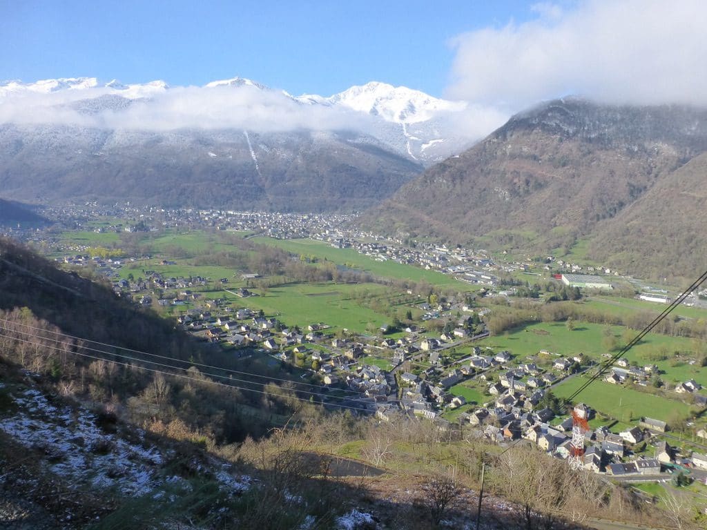
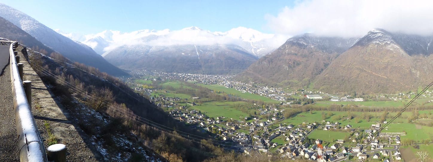
We headed south in steady rain then east along the motorway for a few ks while it snowed, then south along the river valley to the ski/spa resort town of Luchon. We are not actually in the town of Luchon. We are in the small village of St Memet which joins Luchon to the south just over a bridge. (For short hand, I will say ‘Luchon’, which you might have heard of, rather than St Mamet, which you probably have not. But rest assured we are again in a tiny village – so, tiny it does not have a bakery.) Extremely pleasant French couple who we have let the house from. They took an hour to talk about what we can do while in Luchon – hope the snow/sleet/rain stops. This is our first non-absentee landlords since Sarlat and the first French landlords since Collias. It certainly makes a difference to have non-absentee landlords. WIFI at last and the phone works again. I worked at and got week 6 (Cajarc) off. Three weeks late!
A story that I must tell. Luchon has a very busy and long main street with very limited parking. Traffic flow is usually about 10km/h because of badly parked cars and trucks and cars suddenly leaping out without warning. We were creeping along in the line of cars looking for a parking place. The car in front of us found a spot and began the process of reversing. There were cars coming the other way, so I stopped to let him reverse in. It was polite and there really was no other choice. The car behind flew into a rage. Horn blared, lights flashed and he roared past with a shake of his fist. To find himself nose to nose with the oncoming car I was waiting for. Brakes rapidly applied and he slotted in between me and the reversing car in front, which now could no longer reverse and had to drive on. What do you think? Plan and look ahead? I laughed for quite a while. I was a little disappointed that his airbag did not inflate.

7 Apr 2013. Sunday. Day 65. A sunny day. 15C. Well, it did get very hazy from mid-afternoon, but we saw the blue sky! We went for a walk. Our landlords recommended several walks and we headed off to the first of them – with a picnic lunch and a plan B for just in case. And we needed them. The snow had covered the road on the way to the village from where the walk started. Lots of skid marks from cars coming down. 2C. We turned back and did a delightful walk that went in from a bend in the road just above Sode.

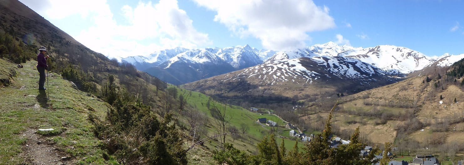
We walked along a road to a bridge. Snow on the ground and trees, waterfalls, birds and deer. When we came out there was a chair on a knoll just above the car so we had our picnic there and watched the recreation traffic on the little airport below us. Five aircraft. We watched a glider take off. Aero-tow in high formation (ie, the glider sits just above the airstream of the tow-plane. In Oz, we tow with the glider below the tow-plane.) The tow-plane took the glider well out of sight to the south. As it was now 15C, we drove up that tricky bit of road to have a look at the start of that walk from Artigue. A very interesting village with many sheep and cows in the street. Then, back down the treacherous road and we could see the glide hill-soaring from the lift of the gentle breeze that was blowing along the valley from the north. The glider, going very slowly, passed countless times back and forth across the slope going up to the ski field of SuperBagneres – not gaining or losing height. Very impressive.

8 Apr 2013. Monday. Day 66. We messed this day up. It began cloudy and 1C and was sunny 15C by mid-afternoon. We headed off at 10am to do a walk along a river. We drove through thick cloud and could not even see the river. It began to snow. We decided that walking in the cloud and snow, not being able to see anything was not a good plan. What to do? We went for a short drive to Col de Peyresourde – one of the ‘minor’ climbs in the Tour de France. It snowed on us most of the way up. As we were coming back, the cloud began to lift. We called in at a recommended restaurant for lunch – it was closed. Down and back to Luchon where the cloud had lifted and we had a sunny afternoon. Bad planning. I hope the weather forecast holds for tomorrow.

9 Apr 2013. Tuesday. Day 67. 20 days to go. Woke to a weather report of rain all day, which was contradicted by the sunny skies. 19C. We walked up from the village of Artigue on the GR10 heading for the ‘Cabane de Saunieres’. An excellent walk. We began under sunny skies, but the northerly wind pushed in a layer of cloud – first below us then above us. Artigue is at about 1200 metres. The cabin is at 1660. We did fairly well until we ran into snow at 1430m. Fortunately, it was much compacted by snowshoes (‘raquets’).

We pushed on until we began to flounder at about 1540m – just a wee 500m short of the cabin. We retreated to the pastures full of sheep to have a picnic lunch. We think the herd had about 100 sheep – all pregnant. They don’t make cheese in this valley, so all those lambs were for income. We are again struggling to work out the economics – keeping and feeding sheep in barns all winter for a few lambs? Hmm. The houses in Artigue bleat. One very nice little Burmese cat – could have come home in my pocket.


10 Apr 2013. Wednesday. Day 68. A beautiful sunny morning with a build up of clouds by mid-afternoon. 23C. We took on the big walk today – an intermediate walk to the east of Lake Oo. (number 25 in the walks book ‘Cazeaux-de-Larboust, granges de Labach, Oo’.) It was to be a 5 hour circuit with a height gain of 430m. Once again we were stopped by thick snow on the track just before the half way point. We had a picnic lunch and turned back. Our height gain was about 430m as we had almost reached the top.

A spectacular walk. After we got back to the car, we headed off to Oo to see what the other end was like. We certainly had the best views on the side we walked. A bit stiff in the knees tonight.

11 Apr 2013. Thursday. Day 69. A warm front came through today – the first major one that I’ve seen this year. Temps soared to 24C. (I’m expecting the corresponding cold front tomorrow, but, I would say that the temps are on the rise. Woo hoo.) We had the day off to go to lunch. We had two recommendations and (by mistake) chose one that was closed still – as most restaurants are. Our second choice was ‘Les Hauts Paturages’ at Artigue which has won a string of awards for 10 consecutive years. Excellent. That is the third time we’ve been to Artigue perched on the side of its valley. It is the most obviously ‘working-village’ that we’ve been to – with its sheep and cow shit down its one street and barns full of bleating animals. We think the animals still in barns are the pregnant ewes close to delivery as most sheep are out on the hill. Helen is still in a fever about how such a village can make a living. As well as the sheep (for lambs, not cheese), there are flocks of chooks and a few cows. We think that Artigue makes its money by being on the GR10 walking track. There are at least two gites hotels that cater for walkers and groups of walkers. The restaurant also helps – we probably ate very local chook.
We think that the ‘walking industry’ might be important (and for us, overlooked). Even in winter, we have seen tens of people walking the GR Grand Routes. Each will need a bed and three meals. All provided by tiny villages along the route. A part of the ‘entertainment’/’tourist’ industry that is a bit hidden.
Another thing. Artigue is a very small village – 20 houses along a single street. That street and the road into it is bitumen. I don’t think I have seen a dirt road in France (except a track into a farmhouse). That hints at a great deal of equality. Every village has a equal access – a bitumen road. In a way, it flows directly from the Department system – 100 departments all roughly equal (except Paris) with no part of the Department more than 2 days’ horse ride from the Department ‘capital city’. We see a lot of equality in France, and a lot of looking after each other.

12 Apr 2013. Friday. Day 70. Another sunny day 25C after a very little rain overnight. Another walk today. This was another recommended by our landlord. An excellent and easy walk from the village of Jurvielle following the route marked 74. The views were spectacular. What really made this walk was the dog. Just as we were leaving Jurvielle on the walk, there was a sharp bark from the last house and out came this large sheep-dog to stand in the middle of the track.

We did not expect it, or know what he wanted at first, but he took us all the way around. Waited at trail intersections to see which way we would go – suggested easier alternatives. He mainly wanted a stick to be thrown for him to catch – any stick, lots of sticks. He wore us out throwing sticks. With the stick throwing, he only ever went forward, he never went back – if he over ran the stick, he waited for it to be thrown again. A stick that went too far off the track was declared ‘lost’. He drank thirstily from streams and sat in the shade whenever possible. He sat with us while we had lunch – took a little very gently from my hand. A very, very nice dog. He then took us back to Jurvielle, waiting for us along the way. He seldom got more than 50m in front of us. He was with us for more than three hours. Quite a treat. When we returned to Jurvielle, he disappeared around a building. I suspect he would have slept all afternoon. That was quite a walk.

To add to yesterday’s comment about bitumen – even the tiny summer hamlet from where we made our descent today – of 4 barns, 3 summer houses (and a permit for 50 cows) had a bitumen road going to it. We discussed the viability of the villages with our landlords. They said ‘we think the EU pays for the new barns’. They also asked the question of ‘why is NZ lamb so cheap’? And the penny dropped for Helen. The farmers are such a powerful political group that France and the EU pays them – by building things. These tiny farm villages are far from economic. The villages/hamlets and summer barns in the hills are all legacy relicts of an old way of intensive farming when most people lived on the land and a family looked after 50 sheep – that had to be put in a barn each and every night and have someone with them during the day. Hay was cut by scythe by teams and was intensive. Spreading on manure in spring was done by hand in spring and took weeks. Both those are now done by tractor and take one person a couple of days. NZ lamb is cheap because NZ does not have the ruinous legacy of old barns and houses to live in and maintain. By economics, almost all the quaint beautiful old hillside villages should be abandoned. But, the farmers are too powerful and they want to stay farming. So, France pays them to stay farming. The French pay more taxes so the farmer can have his new barn. Food in France is extremely cheap at the market, in the shop and in the restaurant – because the French have already paid for some of it in taxes.
I have liked Luchon/St Mamet at lot. The house is probably the best we’ve been in on this trip – practical, modern and all well done. Luchon itself is in a very deep valley and reminds me a little of Queenstown NZ because of all the extremely good walking available around. (It does not have Queenstown’s extreme sports.) Luchon has two ski-hills within easy drive, countless walking trails and thermal baths and spas. (I don’t think the Romans skied or walked the walking trails in the mountains, but they did use the spas and thermal baths.) I have liked our landlords, Christina and Robert a lot. Very friendly and very willing to try to make our stay enjoyable. So very different from having an ‘absentee landlord’ who sends a neighbour in to ‘see if everything is alright’. Robert had popped in several times with a suggestion for another walk. All were good and all were welcome.