Road Trip Queensland 2022
Preparation. This trip has been in preparation for three years. Each attempt was tackled by COVID and we dropped it. Our plan hinges around a Tour to Cape York with Cape York Tours. We depart from and return to Cairns. We will have a couple of weeks just south of Cairns before the Tour and a couple of weeks after north of Cairns after the Tour.
The Van needed new shock absorbers before the trip and that took awhile to have installed. Packing has been easy, mainly trying not to get COVID in the week leading up to departure. There was quite a lot of rain in inland southern Queensland in the month before our departure. Flood water from that had closed roads to St George that I was planning to use. Instead we are going via Goondiwindi and Roma.
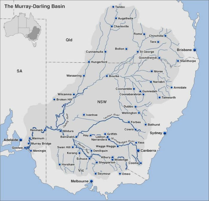
I’m very interested in the map above. I did not know how extensive an area those northern tributaries of the Darling are. Many of those tributaries are rivers and although they spend much of their lives without water, every few years a fall of water in their catchment fills them to overflowing and they flow down to join the Darling as the mysterious Queensland rains. I’ve really only seen the Darling from Bourke down the the Murray. You can see Wagga down south on the Murrumbidgee. We will head north to Dubbo, Narrabri and then Goondiwindi before swinging a bit west to get to Roma. The rivers that flow around St George have cut the road in several places.
Just before we left, quite a lot of rain fell just west of Charleville – in and west of the Longreach area. Notice that water will not end up in the Darling or Murray or any ocean. It is heading for Cooper Creek and Lake Eyre.
Day 1. Thursday 5 May 2022. Wagga to Peak Hill 327km: 3:45h. Most of the way is across the Lachlan River flood plain. Flat, flat, flat. Quite a lot of water sitting around on the ground. The area looks like good farming country when it is not covered in water. From the road reserve, it looks as though the southern part was initially covered with Acacia pendula (Myall) – a very attractive wattle with silvery green feathery leaves. [An indicator plant for deep, non-cracking heavy clay soils.
A reliable indicator of clay soils on the far floodplains of the ancestral rivers. Janet Wild] From just north of Parkes, we swapped drainage catchments into the Darling catchment. (The Lachlan flows into the Murray/Murrumbidgee.) Between Parkes and Peak Hill, the Bogan River flows and it heads for the Darling. We are staying at the Double D Caravan Park. Very clean and friendly. We went for a walk into town and along the main street. Very run down – far more buildings shuttered up than open. Not much here to hold people in the town/village.
Day 2. Friday 6 May 2022. Peak Hill to Narrabri. 300km: 3hr. We were expecting to go via Gilgandra. Our sat nav had other ideas and sent us in a very direct route, though bumpy and narrow road via Mendooran that took 40mins off the trip from Dubbo north. Narrabri is on the Namoi and Dubbo is on the Castlereagh??. Both flow north west to join the Darling. In between Dubbo and Coonabarabran we were in a Pilliga like forest of ironbarks. Surprisingly, it is a Mallee Fowl area. We are in the Narrabri Big Sky Caravan Park beside the river. A lovely sunny warm autumn day. It certainly gets cold when the sun goes down.
Day 3. Saturday 7 May 2022. Narrabri to Goondiwindi. 230km 2:30hr. We are at the van park at 20 Hungerford St. We were here last June. It has got even more run down. The camp kitchen is very ordinary. I took a few pix of Magpie Geese in trees at billabong on park boundary.
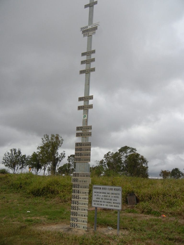
The forecast rain for the next week has us worried. We are planning to head to Roma tomorrow. We intended to stay in Roma two night. Now down to one night. Every night over the next week will have to be reassessed several times a day. We will press on as long as we can. No driving into any flood water and keeping a careful watch on all weather and road warnings. The BOM model that was plastered all over TV yesterday was the worst of 6 models. The others all show a lesser rain fall. The part that has us most worried is what will happen in the Belyando/Burdekin catchment. We have to cross both rivers and both get pretty tall over the road when they flood. We might not be able to get to Charters Towers or Townsville. Watch this space.


Day 4 Sunday 8 May 2022. Goondiwindi to Roma 342Km 3:43hr. We are at the Big Rig vanpark in Roma. We had planned 2 nights here but the rain bomb warnings for central Queensland had us worried and we will press on tomorrow to Emerald. From Goondiwindi, we headed north across flat flood plain of the Balonne. Vegetation quickly switched to Brigalow (Acacia harpophylla). After a bout 100km we turned left at The Gums onto the Surat Developmental Road which was extremely bouncy – still in Brigalow. Not far before Surat, we left the Brigalow (and the bouncy road) and began a very long drive through open grassland with a ‘solid’ soil. We stayed at the Big Rig a few years ago when it was just emerging from a flash flood that had vans hastily removed during the night. Damp and soggy underfoot.
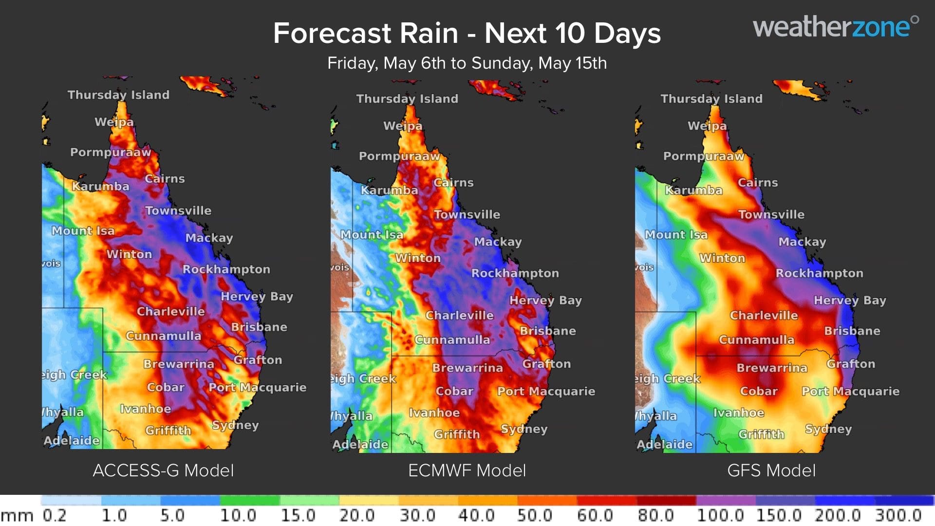
Day 5 Monday 9 May 2022. Roma to Emerald 404km 4:24hr. A long day. Most of the way through open grassland. The exception is the mountain range just south of Carnarvon National Park. Getting a coffee was difficult. We finally got one at Springsure. Arrived in Emerald about 1pm. Very tired. Day off tomorrow. The forecast of heavy rain and flooding tomorrow is on again. Flooding now forecast for all tributaries of the Burdekin (including Belyando). Bugger. From here to Cairns has us crossing the Burdekin/Burdekin at least once. Let us see what the flood damage is by tomorrow night.
Below pix of Burdekin crossing and rain bomb forecast which does not look good.
Day 6. Tuesday 10 May 2022. We’ve paused for a couple of days at Emerald to see what will happen today. The warning and forecast from BOM yesterday was pretty scary. Several of the rivers they listed are flooding across roads that we will travel on. We’ll have to wait to see if we can cross the Belyando (between Clermont and Charters Towers) and then the Burdekin between Charters Towers and Townsville. That is still plan A. If we can’t do that, we can turn off at Clermont and head for Mackay. We then have to cross the Burdekin at Ayr to get to Townsville. If we can get to Charters Towers and then head north to avoid the Burdekin Crossing, we have to get almost to Cairns before we can get to the coast. A few confusing choices. Fortunately, those rivers can go back down again fairly quickly. Heavy rain during the afternoon in Emerald. What to do next is becoming confusing. The road to Charters Towers was closed by 11am this morning at Belyando Crossing. From Emerald, we can go east to Rockhampton; west to Barcaldine; NE to Mackay. It looks as though the rain event will contract to the coast over the next couple of days. So heading for the coast might just be prolonging the problem. On the other hand, inland rivers might take longer to go down than coastal rivers. Belyando could be up for a week or more. Even if we can get to Townsville, coastal rivers to the north are also flooded (Tully and Innisfail). We decided to stay here one more night. Driving through this heavy rain is not a good idea. By tomorrow night, the situation might be clearer. I’ve given up on nights in Charters Towers and probably Mission Beach.
Day 7. Wednesday 11 May 2022. What to do? Things have not become much clearer. It is not raining here at Emerald. We have extended our stay here through to tomorrow. The rain has moved to concentrate on the coastal area. Flooding there is increasing. The road from here to Charters Towers is closed and Belyando and Burdekin Rivers are rising. If we leave Emerald, we can get to Capella or Clermont. Capella has no supermarket. Clermont to Mackay is open as are all roads north from there – except just north of Ayr (Houghton River at Giru). A plan is forming. A walk in the Emerald Botanic Gardens after lunch.
Day 8. Thursday 12 May 2022. Woke up to rain and rain continued all day. We decided to remain here at Emerald yet another day. We are in a safe place here close to toilets, short drive to supermarket. Another day of reading. The road to Charters Towers is partially open. The road to Mackay is still open. Maybe tomorrow will be better. There is no doubt that the van park in Emerald was full and the the staff did an awesome job in keeping people safe. There would have been a constant stream of people arriving each day from the south but people already in the park could not continue their journey to the north. Friendly and helpful.
Day 9. Friday 13 May 2022. Away early. Rain stopped last night. We knew that we could drive at least to Clermont. So, we did. From there we had a choice of two roads: to Charters Towers (still blocked off and on) or to Mackay (all open). We filled up at Clermont and headed for Mackay. Every time we drive along that Peak Downs Highway there are more mines and mining villages; the road is wider and straighter with better bridges and foundation. We had to stop a couple of times for extended periods at red lights for road works. A bit of water over the road just south of Marian was the only flooding we saw.
I’ve had to make several changes to our bookings. We were going to stay at Clermont, Charters Towers and Mission Beach. All cancelled. We will have tonight at Mirani; tomorrow at Ayr (I hope) and then through to Kurrimine Beach. I think we are ok to Ayr but the road is still blocked north of Ayr. Hopefully the flood water will go down. It has been a real shock to come down the range behind Mackay to a solid humid day of 30ºC. Emerald was 19º with rain. Helen said: ‘Aren’t you glad you did not choose to live here?’
Day 10. Saturday 14 May 2022. The flood part of the adventure appears to be over. Drove 290km to Ayr. Quite a lot of road work – especially south of Bowen. They are certainly putting a considerable amount of money into the Bruce Highway. Mainly lifting it out of low lying areas that tend to be flooded. That, and lifting and widening bridges. Every kilometre they work on will help make the road four seasons. Although the claim made for many years that they have done this already, truthfully the road was not passable in the summer wet-season. Tonight, we are in the old Silver Link van park (now a Discovery Park) where Helen spent many months when her mother had a bad fall.