I am Barbegal – a Roman watermill

by | Feb 27, 2013 | France, Road trips

I am Barbegal – Roman watermill

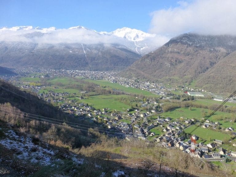
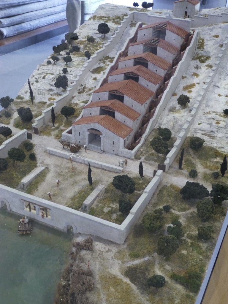
The Barbegal aqueduct and mill is a Roman watermill complex a few kilometres north of Arles. The complex has been referred to as “the greatest known concentration of mechanical power in the ancient world”. The concept was simple, but the application is impressive. Barbegal was an immense flour mill, dating from the 4th century A.D. The power to drive the millstones came from 16 waterwheels, arranged in two parallel rows of eight. Each row ran downhill so that the water dropped from one wheel to the next, driving all eight in turn before running into a drain at the foot of the hill.

Two aqueducts join just north of the mill complex. A sluice enabled the operators to control the water supply to the complex. The capacity of the mills is estimated at 4.5 tons of flour per day, sufficient to supply enough bread for the 6,000 of 30-40,000 inhabitants of Arelate at that time. The mills apparently operated from the end of the 1st century until about the end of the 3rd century.

Present day evidence of multiple mills during the Roman era is rare. The remains of the Berbegal mill and buildings which housed the overshot water wheels are still visible at the site, and it is by far the best preserved of ancient mills. There are substantial masonry remains of the water channels and foundations of the individual mills, together with a staircase rising up the hill upon which the mills are built.

It is thought that the wheels were overshot water wheels with the outflow from the top driving the next one down and so on, to the base of the hill. Vertical water mills were well known to the Romans. The use of multiple stacked sequences of reverse overshot water-wheels was widespread in Roman mines. There were also floating water mills and sawmills.

In her Masters of Rome series, Masters_of_Rome Colleen McCullough has much needed armour made in just such a watermill complex. This one?

Shield Shrimp

When it rains across Australia’s vast inland region, temporary pools crop up all over the arid ground, giving life to a strange desert crustacean known as the shield shrimp (Triops australiensis).

Named after the formidable carapace that shields its head and upper body, T. australiensis can grow up to 7.6 cm long, and it uses its long, segmented tail and mass of 60 or so legs to propel itself through shallow water.

It also breathes through these legs – its sub-class Branchiopoda means ‘gill-legged’ – and in the females these legs bear ovisacs for carrying their tiny eggs.

Several pix in the Photo Gallery and a movie.

Acacia peuce

A rare and endangered plant. The tree grows up to 15 to 18 metres (49 to 59 ft) high, with short horizontal branches and pendulous branchlets covered in needle-like phyllodes adapted for the arid dry climate. It has a distinctive habit more similar to a sheoak or a conifer.

Although speculated to have been widespread across central Australia during wetter climates 400,000 years ago, the population is now mostly restricted to three sites, separated by the encroaching Simpson Desert. In the Northern Territory, the species is restricted to the Mac Clark (Acacia peuce) Conservation Reserve which is surrounded by a pastoral lease, Andado Station. The other two sites are near Boulia and Birdsville in Queensland. The tree is found in open arid plains that usually receive less than 150 millimetres (5.9 in) of rain per annum. They grow on shallow sand aprons overlaying gibber or clay slopes and plains and between longitudinal dunes or on alluvial flats between ephemeral watercourses.


Owen Springs Reserve on Hugh River

Owen Springs was a station on the Hugh River. The Hugh River flows into the Finke (when it actually flows). Both cut through the Western MacDonnell Ranges. The image above shows Owen Springs Reserve as a dot at lower right. The river it is next to is the Hugh. Hermannsburg, our next town, is near middle left edge. Hermannsburg is almost on the Finke River. You can see both Hugh and Finke Rivers cutting through sections of MacDonnell Ranges.

Palm Valley

Palm Valley is within the Finke Gorge National Park southwest of Alice Springs. Palm Valley has a smallish population of Red Cabbage Palms (Livistona mariae). The nearest related species is 850 kilometres away in Katherine NT. The average rainfall for Palm Valley is just 200 mm per year. Small pockets of semi-permanent spring-fed pools allow the unique flora and fauna (desert fish, shield shrimps tadpoles and frogs) to survive.

It had been assumed that the cabbage palms were remnants of a prehistoric time when the climate supported tropical rainforest in what is now the arid inland of Australia. Genetic analysis published in 2012 determined that Livistona mariae at Palm Valley is actually the same species as Livistona rigida from samples collected near Katherine and Mount Isa, both around 1,000 kilometres (620 mi) away. It is now thought that aboriginal people brought the palms to here from Mataranka.

Mound Springs

Mound Springs occur around the Western edge of the Great Artesian Basin and represent a natural discharge of Artesian water that was captured many hundreds of kilometers away from rain falling along the Great Dividing Range and New Guinea. This article provides details. Dalhousie is an excellent example of a mound spring.

Great Artesian Basin map Great Artesian Basin diagram