France 2013 – week 5 – Sarlat
2 Mar 2013. Saturday. Day 29. A day of motorway driving. Frustrating some of the time. We certainly could not get the toll booths worked out. We had to push the help button on the first several booths. We drove about 550km mostly on motorways. All up, that cost us about €35. Unfortunately (for us), several times we moved from paid to free motorways – each time with another round of booths! At Sarlat (which is a town/village in the south of the Dordogne, pron Door-don) we have a magnificent restored room in the roof of a building that was probably built in the 1400s.

We are up 75 winding stone stairs. Called ‘the attic’ (le grenier) for obvious reasons with its old black-painted oak beams and struts.

The place is owned by a very friendly Irish couple. They have done a very good job and the room looks fantastic. We are right in the centre of the old town. The only downside I can see so far is that we don’t have wifi in the room. (I think I will not have wifi for the next 4-5 weeks.) I was very spoilt over the last few weeks. I certainly could not have rebuilt the choir music folder from here.

3 Mar 2013. Sunday. Day 30. A sunny, clear warm day – well not warm enough to be without a heavy coat. A day of not doing much after that long drive yesterday. We had a walk through the delightful town/museum of Sarlat. We followed Rick Steves’ walking tour. Yep, Rick Steves is still with us. I’ve worked out he will be with us for at least 8 of our 12 weeks with very informative descriptions. (He suggests spending a minimum of 3 days in this area where we will spend 2 weeks.) Sarlat has been a town of major importance in the region since about 1,100. It had a bit of a climax with the 100 years war (when it sided very loyally with the French French side), bump up in population and an injection of funds. Then, decline as with most of southern France. All was saved when, during WWII, a future government minister wandered these almost abandoned villages in his resistance battle with the Nazis. He later introduced laws to preserve the hill-top villages and bastides.

Restoration followed in the 1960s. By the 1970s, as hoped, tourists found the region and had something to look at. Thus, a new industry – tourism – one of France’s main exports. Helen thinks that Sarlat in winter looks like a ski-village (in the off-season). Sarlat in winter is almost deserted. Locals are absent and on holiday before the region is swamped with visitors and locals get to work very hard for a few months – just like a ski-village.

We lunched at the recommended La Mirandol (along with several others who we had seen on the walk – though we do tend to go much slower). Helen had fried duck livers, cepes (mushroom) omlette, duck breast with truffle gravey. I had foie gras, snails in mushroom sauce, goose leg (thigh and drumstick). Followed by a small goats cheese and a slice of lemon tart. Extremely good. Staggered home and climbed our 75 steps to our room.

We headed off to a 5pm afternoon concert that was a very short walk (40m) away just above the TI (Tourist Info). A cello/piano duet – an audience of about 75 people. It was excellent. The cellist (Cedric Leprevost) was wonderful. I don’t think I’ve heard better and I was siting 3 metres in front of him. Wonderful to watch. An interesting program that showed off the cello and his playing of it – slow, fast, slow, faster, slow. Composers such as Faure, Schumann, Rachmaninov, Bach, Sarasate. The pianist (Laure Boire) did an excellent and difficult job of accompanying. The building we were in was built around 1600 – before any of the composers were born. (Bach is the earliest – born 1685.) The gig was put on by the local music society – we suspect funded by France. We must go to more of these.
A bad end to the day when the Mac would not wake up from sleep. A bit of an anxious time. I eventually got it up tomorrow afternoon after trying a few very technical boot options. I have no idea what was wrong or what I did to get it to fix itself. I works again. Hurrah.
4 Mar 2013. Monday. Day 31. A clear sunny and warm day 20C. Short sleeve shirts. We headed off for a bit of a drive along the Dordogne River. Sarlat is sort of on the middle of the Dordogne and makes an excellent base to see things from. To the north (along the River Vezere) are caves such as Lascaux. To the east is the Dordogne and to the south is the River Lot (see next week). For some chunk of time, the Dordogne River formed the border between France and England. Or to qualify that, it formed the border between two waring French lines of kings – one of whom lived in France, the other lived in England. The battles comprised the 100 years war.
Refuelled the car. Driving on the motorway at 130 km/ hr and driving about 1 1/2 hour of winding roads to and from the motorway, we averaged 5.97 l/100 km for the 508 km trip. Average so far for 1,448 km is 6.29 l/100 km.

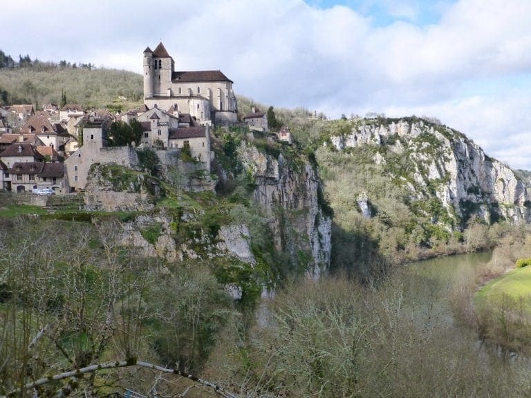
Clutching Rick Steves’ guide book for the Dordogne River Sites, we headed off first to the Bastide of Domme (which we had seen before and was deserted) then to La Roque-Gageac (lah rohk-gah-zhahk) ‘the most beautiful village in France’ (and there would be a few lining up for that title). It was seeing this little village during the Tour de France that greatly influenced us coming back to see more of the Dordogne. (That, and the food and a few other things.) There is no way to put this gently – La Roque-Gageac was disappointing. It is on a majestic sweep of the river, on the outside of a bend and overhung by a sheer cliff.

In winter, the river floods and tries to carve more of the bank and town away. In 1958, some of the sheer cliff broke away and squashed some of the town. This is where it gets interesting. The French government then decided that the most beautiful village in France must be revived and threw money at it. Now, to deal with the river’s threat to ‘the most beautiful village in France’, the French, EU, Dordogne and Aquitaine governments have thrown about $A1 billion to fixing its major tourist attraction. For us it was a dust bowl of road works. I hope it is fixed by summer.

It was getting late, so we decided to have a quick look at the French side of the border – the castle/village of Beynac. The gps went crazy. The road through La Roque-Gageac was closed and the only way to get to Beynac was back through Sarlat. We had about 15 mins of ‘do a u-turn’, ‘turn right’ into a farmyard, ditch, hay loft. We followed a few furiously driven workers cars that had pulled up at the only open restaurant in Beynac. Very good plat du jour lunch beside the river at Beynac. We left at the same time as the furious workers cars that led us back to Sarlat. Back home to fix the mac. Hurrah again.

5 Mar 2013. Tuesday. Day 32. Cloudy and extremely windy. Just the right day to visit an exposed castle and a garden. We set off, clutching Rick Steves, to visit Castelnaud – which played an important role in the Albigensian (ethnic cleansing) crusade of the 13th century, the 100 years war (when it was held by both sides) and the even more bitter ethnic cleansing Wars of Religion (1562-92). Burnt many times, restored many times. Now an excellent and interesting museum devoted to castle warfare of that chunk of history. i-am-castelnaud-castle
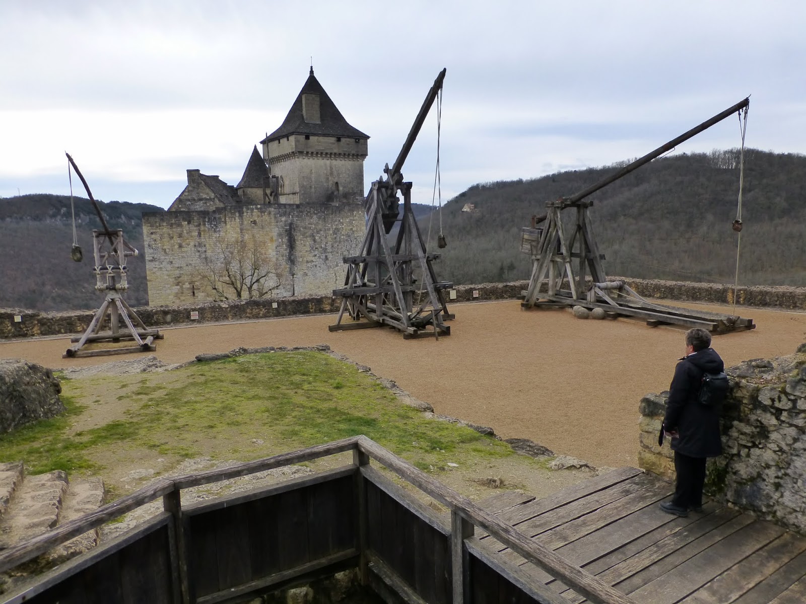
An interesting look at the development of technology on how to kill and not be killed. Clambering up and down very narrow stairways and through very narrow passages – part of their idea was to show what living there might have been like – cold, hot and unpleasant I would think. A tad windy whenever we got to the tops of things – might be why all my photos show signs of movement – trying to take photos while being blown off the battlements.

Then. we went to the delightful Gardens of Marqueyssac which occupies a spur that runs for a bit more than a kilometre along the Dordogne River to reach its height above one end of La Roque-Gageac. Delightfully rounded and manicured box-hedges. Unfortunately for us, the lookout at the end was closed because of the very strong wind. A picnic lunch in the car to keep out of the wind. Did I mention that it was windy today. It turned out that our landlord’s recently constructed garden shed blew down during the morning in the wind.

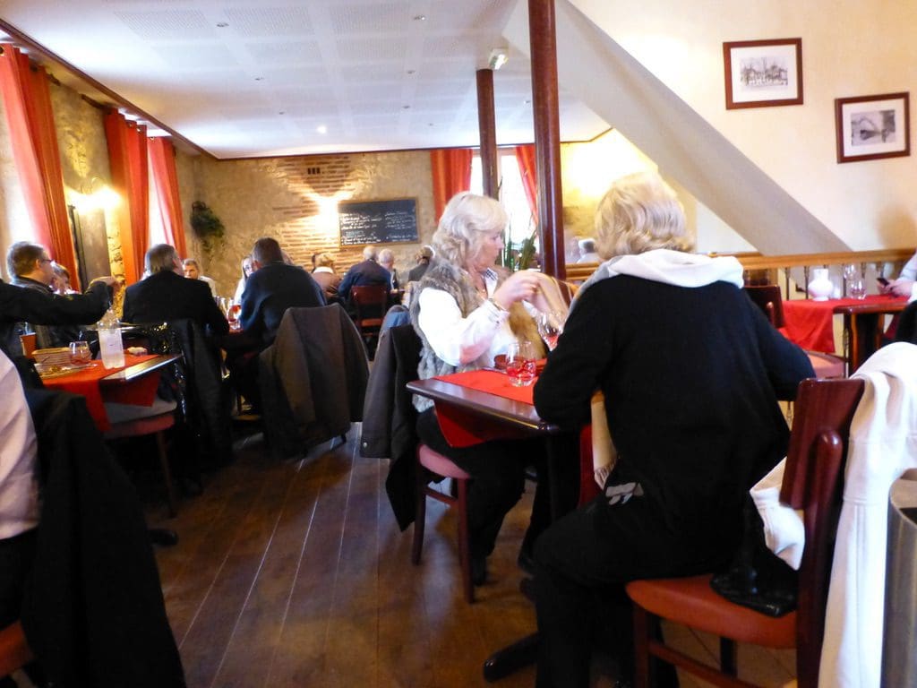
6 Mar 2013. Wednesday. Day 33. Rain. Temperatures still mild in the mid teens. Wednesday is little market day in Sarlat. (Big market day is Saturday.) It was a tired (though friendly and good humoured) market that was struggling to get itself started in the rain, in the off-season – short of small change. We had intended to visit a local house/museum but contrary to its brochure (and as accurately noted by the Tourist Office), it was closed. We wandered through town to our chosen (recommended) lunch place Le Bistro de l’Octroi which has stood on its intersection just outside Sarlat village centre for a great number of years and which opened at 12 noon and was full of locals by 12:10. (We walked in just as the 1st Wednesday of the month fire alarm was sounding. The restaurant was full by the ‘all clear’.) Magnificent bistro meal. Opens 7 days a week for 7 hours every day of the year. Four courses for €19.50. How do they do that? We had a bottle of a local wine Baron d’Ardeuil (merlot with Cab Franc and Cab Sav). I slept for the afternoon. Wiped out by that meal.
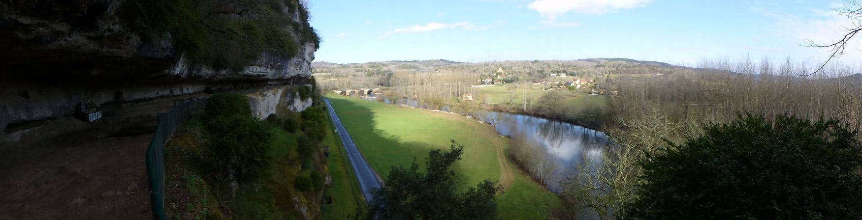

7 Mar 2013. Thursday. Day 34. A beautiful sunny day 22C. Lots of washing hanging out today. First we drove to La Roque Saint-Christophe which is a rock shelf that has been occupied by humans for 55,000 years. An absolutely beautiful setting above the River Vezerie. From 976, it became a fortified town for defence against the vikings who raided along the river. A clever series of watchtowers gave warnings (in less than 6 minutes) from as far away as the junction with the Dordogne River.

The town that occupied the shelf was about 1 km long and in 5 levels and was fully self-sufficient with butcher, baker, etc. Nothing of the old village remains (except holes in the walls). It was burnt several times – during the 100 years war and the later wars of religion. (It looks as though it was difficult for anywhere to be on the right side all the way through that series of civil wars.)
On our trip to France in 2007, we camped at Le Paradis just couple of ks away from La Rocque. Then, we had a very different trip and that had us talk about what an amazingly diverse area the Perigord (Dordogne) is – certainly in summer. There is so much to do. It would not matter much where you plonked yourself down, there is so much to do. However, each place that you do plonk yourself down in will give you a different experience. Camped beside the Vezerie, we had a pre-history experience of cave paintings. At Sarlat beside the Dordogne, we have had a civil war experience.

We had a picnic at La Roque and because it was a beautiful day, we went for a drive. We drove up to Brantome (of which more later). This drive took us from Perigord ‘black’ through Perigord ‘green’ to Perigord ‘white’ – all within the same Department – but with distinct different of soil type, agriculture, food and way of life. Perigord ‘green’ has big extents of ploughed farmland. ‘White’ – has ploughed farmland with bits of chalk poking out. ‘Black’ is the foie gras and truffle area renown for its food – where Sarlat is. When we were planning the trip, we had initially planned to stay at Brantome. We could not get in. Brantome is village in a loop of the River Domme. It has more restaurants than houses – many 1 or 2 star.
Along the way and very soon after we had had lunch, we drove through the tiny village of Plazac. It must have an excellent lunch restaurant. Five work trucks, 25 work cars and about 30 other cars were all parked outside. Just what we are looking for. But how to know about them ahead of time.
8 Mar 2013. Friday. Day 35. Rain and cloudy early clearing to sun in the afternoon. 14C. We went for a drive to the east and the headwaters of the Dordogne River in the Massif Central. Very winding roads. We gave up and returned to Sarlat. Along the way – between noon and 1pm, we found another tiny village with its restaurant surrounded by workers cars. As I say, how to know about them in advance.
The Dordogne is a beautiful place, even in winter when much of it is closed. Sarlat is a very good base to explore the Dordogne River and to a lesser extent the caves of the Vezerie. This little attic is a delight and just what we needed. Very central in Sarlat. Very clean and well looked after. Quiet extraordinary to be able to live amongst the old oak beams, walk up and down the 75 spiral steps and step out into the old restored museum of a town with its twice weekly market.