Simpson Desert Trip June 2019 – week 1
Wednesday 19 June 2019 – Day 1

The adventure begins. 6:30 am breakfast call at the Mercure for an 8 am departure. Bags slotted into the ‘luggage’ vehicle. We are 15 and 5 drivers in 5 vehicles. We have a ‘kitchen’ vehicle (driven by tour leader and chef – Dean), a ‘shower toilet’ vehicle (driven by Bill) and a luggage/supplies vehicle (driven by Paul). Those 3 vehicles are 6 wheel drive Mercedes and there are two four-wheel-drive passenger vehicles (also Mercedes, driven by Lee and Alex). All bucket seats.

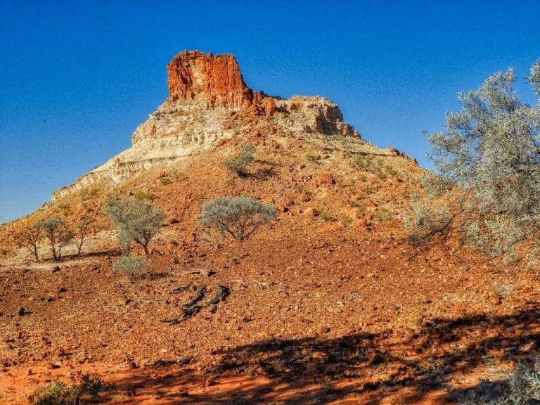
We drove south of Alice along a dirt road to Chambers Pillar – a large solitary pillar in the desert that is the remnant of a Mesa. The area is dotted with Mesa forms with several almost pillars and columns. The country has recently had a good rainfall (30 cm about a month ago) and is looking good but much had dried off in the severe drought leading up to that rain. Where we stopped for lunch was beside a rocky knoll that I think was heavily folded limestone with many inclusions of breccia and some round fist-sized pebbles. Very interesting.

The track from the turn off to Chambers pillar had been newly graded (we passed the three graders) and so in good condition. The ‘normal’ order for our convoy is Dean’s kitchen truck, Lee’s 4×4, Paul’s utility (luggage and fuel) truck, Alex’s 4×4, Bill’s ablutions truck. Today, Helen and I were in Lee’s 4×4. We got to move one place clockwise in the vehicle at each stop. Thus forcing us to talk to other people. A walk around and up Chambers Pillar in the late afternoon light after we had put our tent up. Chiming wedgebills.

Left is a part of the geological map for around Chambers Pillar (about centre). Maryvale/Titjikala is top right. The track follows the line of Precambrian rock (top right to lower left). Chambers Pillar is much younger Carboniferous Santo Sandstone. All topped off with sand.
Thursday 20 June 2019 – Day 2
 |
| Dry Finke River bed |
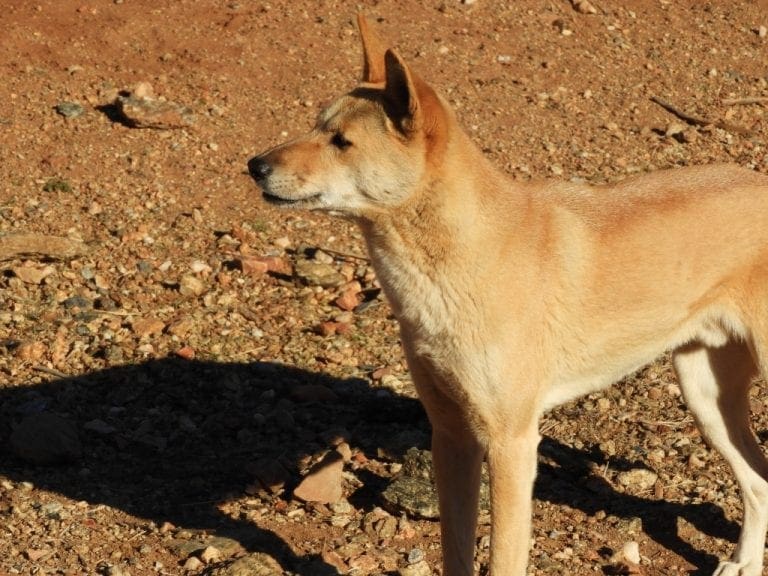
The standard day is going to be up at 6 am, breakfast at 7 and departed by 8. (Called 6-7-8) If we pack up quickly, we walk ahead of the trucks until they pick us up. Along the newly graded road we found fresh dingo/dog tracks, scorpion tracks and saw a chiming wedgebill. A short stop at the Titjikala Art Centre at the turn off to Chambers Pillar. An interesting art centre with several good painting.
 |
| Road with Finke River racetrack to right. |
We drove SSE along what was the old Ghan rail-line. When it closed, the rails were removed leaving a well formed road. Remaining rail spikes are all along the road and can puncture tyres. The long Finke Race Track runs either side of the road. Lunch was in the dry Finke River bed. Last night, we were assigned vehicles by drawing cards, and today we also did the clockwise rotation after each stop. This is an extremely good way to force cliques and couples to talk to other people and turned out to be a major success factor for the trip.
 |
| Finke River cutting through MacDonnell Range |
The Finke River is thought to be the oldest river in Australia. It has cut a gorge through the West MacDonnell ranges and so must pre-date their uplift to what was a Canadian Rocky Mountain sized range – the river’s erosion easily keeping pace with the folded mountains rising around it. A very old river. Next stop was Finke itself – site of the finish of the ‘famous’ Race. When the old Ghan ran through Finke, the rail bridge over the river at Finke was washed away many times – stranding passengers for weeks and cutting Alice off from supplies.

On to Mount Dare where we spent the night. Meal at the pub and a quiz – both excellent. Before Mount Dare we had about 30 km of very flat, flat country with no vegetation which looked odd to me because we had been in undulating country with quite a lot of different vegetation – sometimes sandy and an occasional jump-up. For much of the way we were on (actually on) the old Ghan rail track.
Dingoes howling tonight.

Mount Dare hotel is surrounded by a levee. According to the pub owner, the quiz we did tonight was made up to entertain 40+ people who were stranded here recently for more than a week when the Finke River flooded. Mount Dare is top centre of the map left. Bright orange patches are Tertiary silcrete – formed by millions of years of roasting in hot, dry drought.
 |
| Horst and Graben country around Dalhousie Springs |
Friday 21 June 2019 – Day 3.

From Mount Dare to a campsite between dunes on the French Line in the Simpson Desert. I was in the kitchen truck driven by Dean (our cook and tour leader). The usual 6-7-8 start and we begin walking along the road at about 7:15. The trucks picked us up at about 8:10. We had walked 4.3 km. The country around Mount Dare is flat with no sight of anything that might approach a small hill – let alone a mountain. The road is built on top of mud.

We drove to Dalhousie ruins and then on to Dalhousie Springs for lunch, a swim and a walk (quite an interesting vegetation group including samphire and a cushion plant). The water in the Springs is a magnificent 30°C+ with quite a strong flow through the huge pool (200m x 50m). It has steel steps to get you in and noodles are supplied. A few little Corellas asleep in the trees and swallows and martins swooping around the water, very small fish nibbling skin.

From there to Purni Bore with a short stop. Purni Bore was sunk in 1964 by French Petroleum (that built a road to facilitate the movement of oil search crews across the desert dunes) to 1800m. Water comes out at about 98°C and did flow freely until recently forming a wetland (now dry) and a rock like substance is forming (in just 56 years).

From Purni Bore we soon entered the Simpson Desert. At the bore, tires were deflated and tall sand flags put on the vehicles (so we hopefully avoid a head-on with vehicles coming the other way at the top of a dune). We switched to UHF channel 10. To cross we need a special permit.

After many kilometres of flat mud and the occasional stony ridge, the sand dunes gradually appear, become closer together and taller as we go east. Until the dunes began, we had almost no vegetation on those mudflats – just low saltbush and acacias in places (even a small stand of gidgee). With the sand, we suddenly got Spinifex (triodia) and canegrass which appears to stabilise the dunes.
We camped between dunes about an hour after we left the bore on a flat area that is large enough for the five trucks and tents.

Saturday 22 June 2019 Day 4


A cold morning at -4.5°C. Another 6-7-8 start but because of the cold everyone was a bit slow at the start with much complaining about ‘never been so cold’. Kangaroo and crocodile sausages for breakfast. We began walking at 7:15 and we were picked up just after 8 when I had walked 1.9km and we were at the junction of the French Line and the Rig Road. I traveled with Alex today. We took the Rig Road and stayed on it for much of the day.

Because we first went south along an inter-dune ‘swale’, we moved away from the steep dunes of the over popular French line – making it easier on the trucks and us – and a head-on less likely. Towards the end of the day we heard a radio call from the vehicle with a broken chassis – apparently this is a common incident along here with an overloaded dual cab vehicle. Because it is in the National Park, the vehicle must be recovered and will certainly cost a lot to recover if it is outside the area covered from Mount Dare.
 |
| Vegetation profile dune to dune |
375 dunes counted by Alan today. Dunes run fairly well N-S and are several kilometres long. From the windward (west) side each dune is less steep then from the leeward side. The windward also has a thin layer of loess (powdery wind blown particles) covering it in big patches – cane grass clumps and spinifex help to stabilise it. The leeward side is steeper and also has canegrass and spinifex. Between the dunes is covered with loess. These swales are variable in width and support a bewildering number of low shrubs – mainly acacias, eremophilas, grevilleas and hakeas. This vegetation cover has pinned the dunes in place for thousands of years.

Later in the day we turned right onto the Rig Road heading east up and down dunes and crossed a salt lake that had water in it six weeks ago when the last trip came through. Some flowers. White-winged wren.
Sunday 23 June 2019 Day 5


It was an excellent campsite last night. Into the main part of the Simpson today. Another 6-7-8 start, warmer morning at 2.5°C. We begin our walk across a salt lake before joining the road and walked 1.2 km before being picked up by the trucks. These morning walks gives us a great chance to poke about at things. Lots of gypsum today which does appear to be related to the gidgee and causes a much rougher road. Continued along the Knowles Road which winds its way along dunes and swales heading gradually NE until we came to the Knowles Knobs themselves where we stopped for morning tea.

Crimson chat. We headed off – now along the French Line where it gradually became dryer – more exposed sand and the dunes closer together and steeper. The sand is no longer as stabilised by the cane grass – either no canegrass at all or the canegrass with exposed roots (windward) and being buried (leeward). Not far along the French Line one of the trucks failed to take a dune in the first attempt and the second.

The fuel tank of the kitchen truck has been pierced and torn and is leaking. It has been plugged with with soap and we continue to Poeppel Corner – more soap. We have no possible repair until Birdsville 1 1/2 days away.

Poeppel Corner marks the corner of South Australia to the south, Northern Territory to the west and Queensland to the east. A T-junction. We had lunch here. A lot of flies. The flynet is necessary and we all (including the drivers) have them over our heads.
The ‘Dark Emu’ book says that European explorers found a village just south of Poeppel Corner with living space for 5,000 people. I certainly find it hard to imagine an agricultural system in this difficult country that would feed so many people.

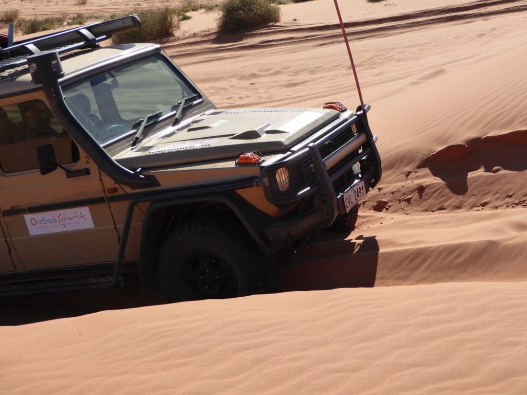
Onwards for just over an hour after Poeppel Corner along the K1 line, and stopped as usual at about 4:15pm. I was in the Ute this afternoon with Paul – ex dairy geneticist and dairy farmer now driving the difficult truck on the Simpson for Outback spirit. The Ute has 7.3 tons of load and can easily break springs etc if not driven well across this difficult country. It does not track well up a dune because the back is always falling towards the fall line and dragging the nose off-line. Bumps must be approached with care and oscillations avoided – else broken springs.
Sunday 24 June 2019 Day 6

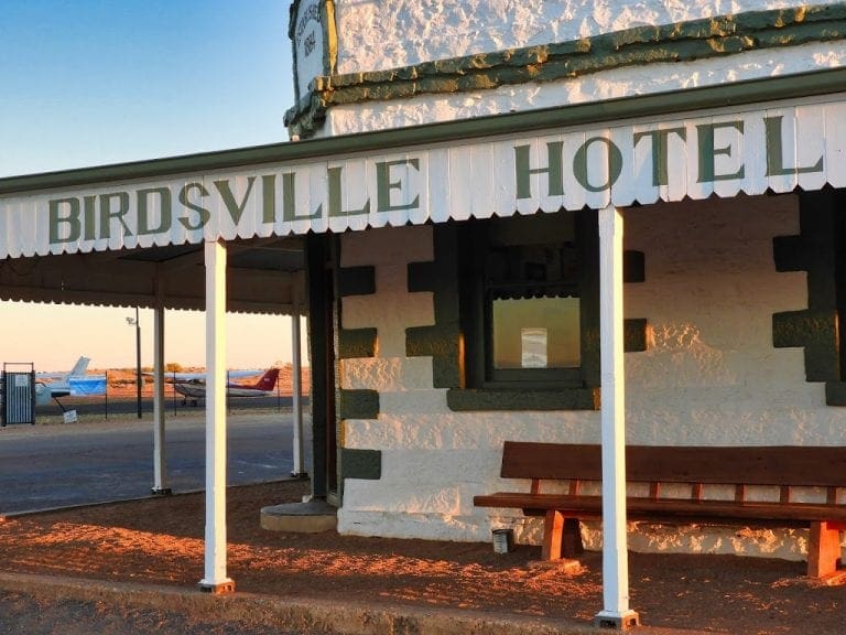
Today we crossed Big Red and arrived in Birdsville. Another 6-7-8 start. They certainly feed us well. We have bacon & eggs for each breakfast. I washed up (again). People are gradually discovering that they can wash up – it is part of the adventure to join in.
 |
| Eyre Creek with water sand dune in background |
A long grind this morning, because the Diamantina/Warburton is in flood, we had a considerable detour, most of which we repeat in two days time – in reverse. The original itinerary was to go SE from Poeppel Corner to cross the Warburton and then take the Birdsville Track to Birdsville. Cyclone Trevor dumped considerable rain into the Diamantina up near Winton back in March and consequently that Warburton crossing will be closed for a few more months.

-1°C this morning for our walk – spiders and insects were in a cold freeze. We headed from our campsite along QAA Line. (These tracks – QAA, WAA, K1, French Line were seismic shot-lines used in the 1960s for oil exploration by French Petroleum.) Sand dunes with decreasing vegetation and swales often very wide with no vegetation. We are in Queensland now and every couple of kilometers there are UHF call-ahead markers counting down to Big Red. Quite a lot of oncoming traffic. ‘5 vehicles heading east at call point 23’. I think this safety system should be in place throughout the Simpson.
 |
| Kitchen truck pulling Ute over dune top |
Because of the steeper dunes, our convoy order is changed today – kitchen and ute lead so that if the heavy ute becomes stuck, the kitchen truck can back up and pull it over. This happened often.
After about 80kms of up and down sand dunes, we reached our detour up Eyre Creek. Saltbush and lignum for about 2 km before we reached Eyre Creek which has many channels and we followed a dry mud bed for 27 km north to where there was a crossing. Many braided streams separated by sand dunes.

Where there has been recent water there is a sudden explosion of green forbes (ground hugging plants that will be dead in weeks). The lignum was in flower in parts. The crossing was just possible for the trucks – any deeper and it would have been off. Lunch just over the creek. Caspian terns and black-faced wood swallows. I traveled with Lee today.
 |
| Big Red |
After lunch, we returned along the east side of Eyre Creek to rejoin the QAA Line with some tall dunes. Most covered with canegrass again. The dune before Big Red was the first we saw with considerable exposed sand at the top. Big Red itself is exposed sand all the way up and down and is the only ‘Sahara’ type dune that we saw. Big Red is certainly the biggest and reddest and hardest to get over. Our trucks put on a bit of a performance for us – many photos and movies. The sand on Big Red is well rounded and has many particles that are not silica – very fine grained windblown sand.

From Big Red there is a good dirt road (some bitumen even) into Birdsville 33 km. The Big Red Bash is held on the claypan immediately leeward of Big Red.
Alex gave us a guided tour of the town. The Diamantina certainly floods the town often.
Shower and washing machine at the Birdsville pub.
Today I took more pics and movies than any previous day of the trip. It may have seemed same – same, but it was very, very varied. Alan counted 950+ dunes across the Simpson Desert.
 |
| Simpson Desert dunes Poeppel Corner top leftish |
This link will take you to a short slideshow of this part of the trip.
This link will take you to a movie of this part of the trip.