Kimberley Trip 2017 – week 9 – Gibb Trip 2
This blog is of the second half of our 16 day Broome to Broome Gibb River Road trip with Kimberley Safari Tours. This blog covers the Gibb River Road itself.
 |
| Pentecost River Crossing |
Tuesday 20 June 2017. Day 55. Gibb Day 8. El Questro to Ellenbrae Station. First a dip in Zebedee Hot Springs which was extremely pleasant. Then, on to a walk over boulders up to Emma Gorge (some had a swim) and back. Quite hard on the knees and I am finding any time in the hot sun extremely difficult. A good lunch sitting in the picnic area at Emma Station. Then, we left comercial-minded El Questro and headed off along the Gibb River Road proper. Crossing the iconic Pentecost River at the designated crossing for many photos with the Cockburn Ranges as backdrop.
 |
| Cockburn Ranges |
After crossing, Matthew backed the bus a little way back across for good photos of ‘our crossing’. The Pentecost River was nice and low and the crossing was easy. Then, onto Ellenbrae for the night. The two young managers (Logan and Larissa) put on a feed for the two tour buses (36 of us) and Logan gave a very good talk about life on the station. Excellent. The million acre station has about 5,000 head of shorthorn cattle and has not been mustered for 5 years.

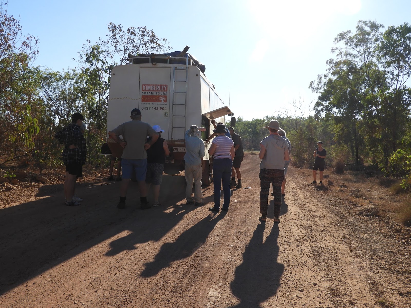
Wednesday 21 June 2017. Day 56. Gibb Day 9. Ellenbrae to King Edward River campsite. We first called in at the Ellenbrae Station Homestead to say thank you to Logan and Larissa and to pickup a bundle of their world famous scones. From there, we slogged our way along the Gibb River Road until we turned off onto the Kalumburu Road (which we take across the Mitchell Plateau). We had a short break at the junction (where some arseholes had left a fire burning full of empty beer bottles). We crossed the Gibb River.

Although the Gibb River Road is rough, the Kalumburu Road is far worse and is very hard on the vehicles. It is no wonder that few tour companies come up this road. After a few hours, we turned left onto a track which we followed for another hour (50km) to the King Edward River campsite, a very late lunch and a swim. Quite a lot of birds here and therefore I will rate it as the best campsite yet. An owl hunted around the backs of the chairs while we were sitting around – and it fed a noisy youngster.
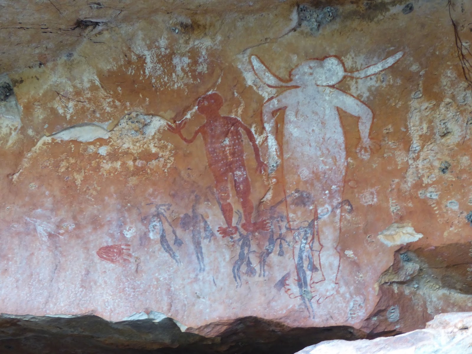
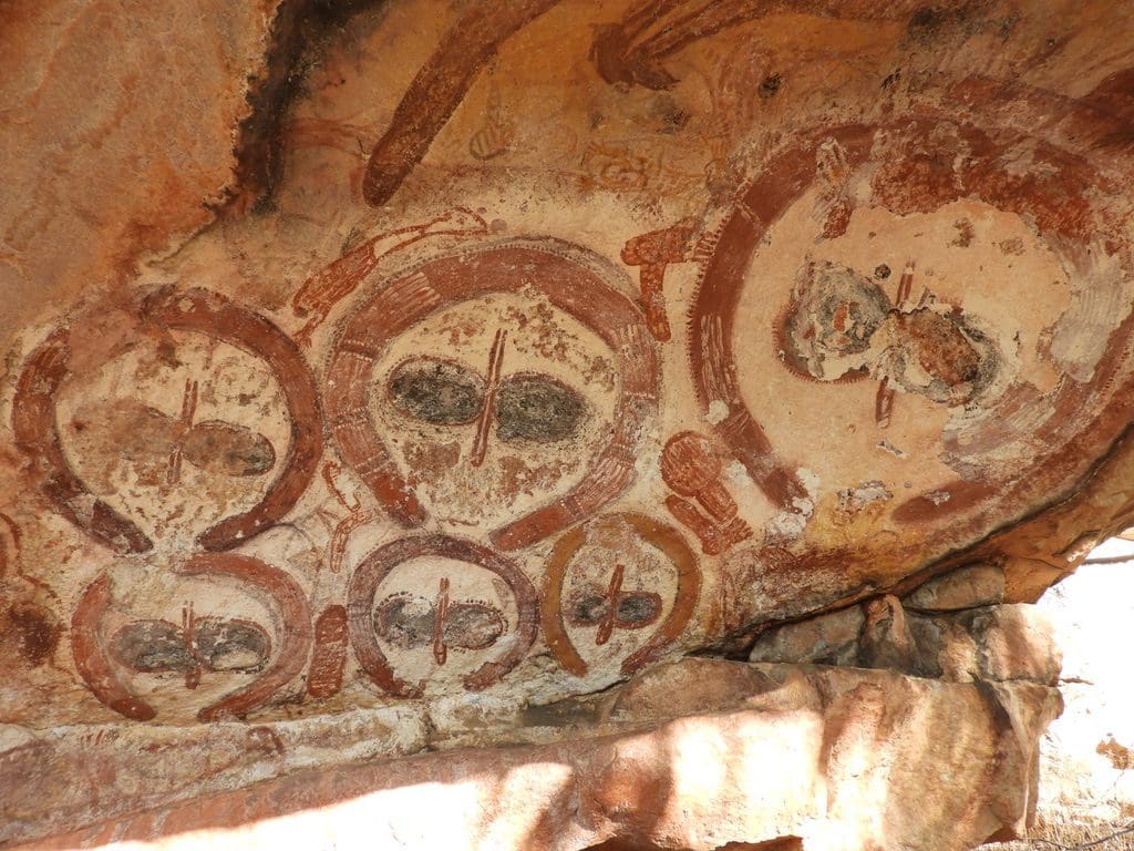
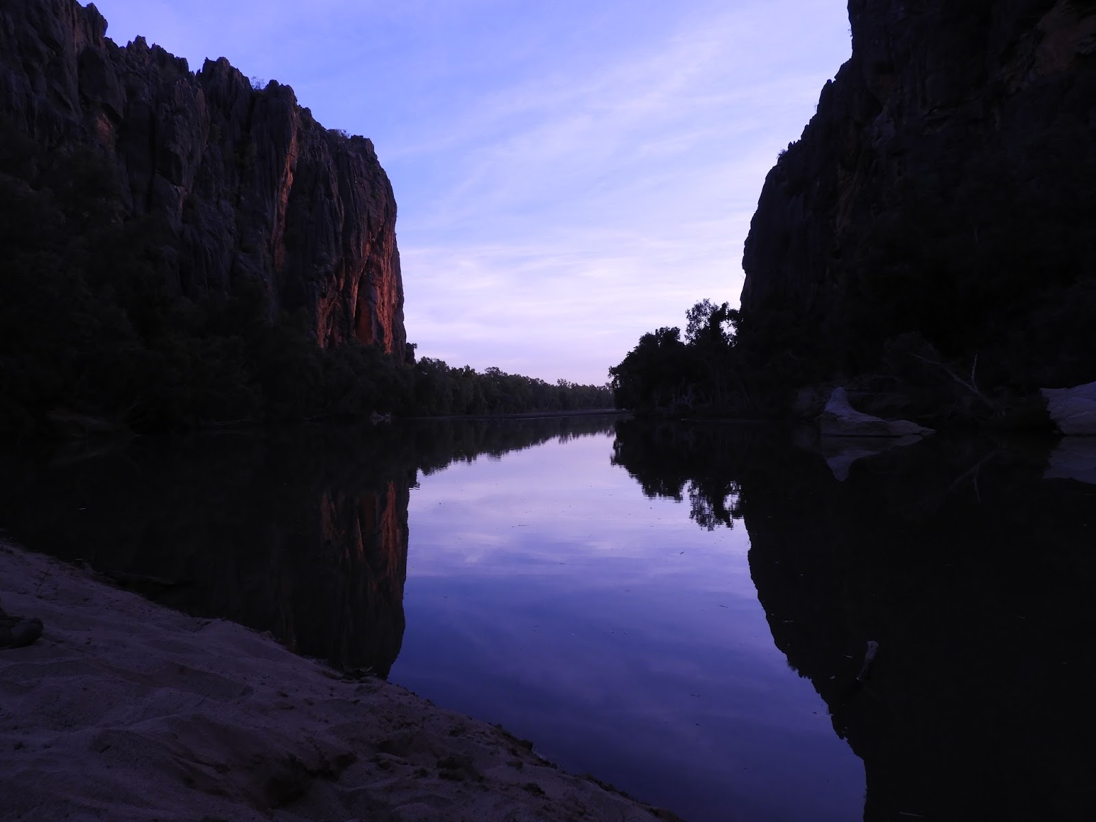
Thursday 22 June 2017. Day 57. Gibb Day 10. Was to have been Mitchell Falls. However, the other Kimberley Safari Tours bus that we have been travelling with for the last few days developed a hole in its radiator yesterday. After much work, it is now believed patched. That group has taken our bus up to the Falls today and we will explore rock art today and have Mitchell Falls tomorrow. That means three nights here at this delightful campsite. (I did notice that although we have given up our day so that the others could have theirs, only one of them thanked us for it.)

I had an excellent hour or two sitting by the river reading. We had a hot morning trying to find a bit of shade to sit in. In the late afternoon, we drove off a few ks to visit some really excellent Aboriginal Rock Art, certainly the best that I have ever seen and a real highlight for the trip. More images. (I think it featured on a TV program ‘First Footprints’.) The road to and from the rock art sites is atrocious and proved that the attempted repair to the radiator did not work.

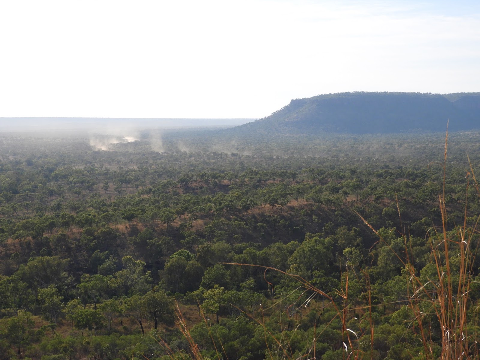
Friday 23 June 2017. Day 58. Gibb Day 11. Mitchell Falls – an excellent if long day. Early start (away at 6:40am) for our 3 hour (60km) drive to the Mitchell Falls site. Our helicopter flights began at 10:30. Helen and I flew at 11:15 for 3 orbits over the falls before landing at its top. A short walk, swim and lunch before our return flight at 3pm. Getting changed out of bathers al fresco was a challenge with helicopters flying over with cameras firing out of open doors. We had chosen the very worthwhile ‘extended’ trip back on the helicopter which flew us down the Mitchell River to the lower Mitchell Falls below which the river is tidal and has saltwater crocks (which jumped into the water when they heard us approach) and from where we could see the Timor Sea. The country is incredible, difficult and extremely hostile.

A basalt that has been heavily lateritized overlay a coarse-gained sandstone that has been chopped up by enormous cracks. Livestonia palms and eucalyptus growing together – very sparse to closed canopy. The palms are restricted to the basalt/laterite. It would be extremely difficult country to stock. It would probably support one cow to the square mile and break all the horses legs. We then had the 3 hour drive back to camp over that very difficult ‘unmaintained’ road through/over that laterite. Very trying.

Saturday 24 June 2017. Day 59. Gibb Day 12. King Edward River to Manning River. Another long drive. First, while crossing the King Edward River, we picked up a rock between the rear wheels of the bus – the outer wheel had to be removed to get it out. Then, the heavily corrugated Kalumburu Road down past Drysdale Station to the three-ways where we met the much smoother Gibb River Road and followed that for another couple of hours to the Mount Barnett and the Manning River – where we arrived at dusk.
Troubles continued with the other truck which we found at Drysdale with people under it. That radiator was still leaking from a fatigue crack in one of joints. The araldite from the previous day had not worked – having been applied over oil and dust. One of our fellow passengers was a welder in a former life and we left him (and two others) to effect repairs and took up four passengers from the other bus who were keen on making their escape. (One of whom was extremely insistent that the Blue-winged kookaburras that called at sunset and sunrise were brolgas!)

The country we drove through was an open savannah with a thick grass cover. Unfortunately that grass is of very poor nutritional value and the extremely dry and hot conditions means that cattle are confined to narrow watercourses – most of which dry up by the end of the dry. The Manning River campground that we are in is a very busy one. Most Gibb travellers will stop here. It is beside a river, has hot showers and running water and is a short walk from the Manning Gorge (one of the Gibb attractions).

The welding repairs to the bus were unsuccessful and the bus limped into camp at 8:40 having had to top up its water every 1 1/2 hours. The buses certainly take a hammering on these roads. Having to conduct such temporary repairs is common and Matthew had to spend $6,000 on repairs between trips. Of the two buses, the one we are in (longer wheelbase) is much better on these roads as it handles the corrugations better. The small bus, with its trailer, has a difficult time on corrugations and the trailer adds its own set of bangs and problems. Anything towed has a habit of disintegrating.
 |
| Manning River |
Sunday 25 June 2017. Day 60. Gibb Day 13. At Manning River. Most of our group walked up to the Manning Gorge for a swim. Helen & I stayed in the camp and caught up on washing. After lunch, the other bus left – and we hope that is the last that we see of it. We sat around in the shade and most of the party went off with our bus to collect firewood (and have another ice cream at Mt Barnett). We went for a swim in the river. I think that one of the main reasons that many fall in love with the Kimberley is the swims. Many/most/all of the side trips or places to stop involve a swim. There might be a difficult road or gorge to navigate to get there, but there will be a swim at the end of it.
 |
| Galvans Gorge |
Monday 26 June 2017. Day 61. Gibb Day 14. Manning River to Silent Grove. A day of two magnificent gorges. First, to Galvans Gorge which is a beautiful spot and is extremely bird rich with many species being able to find a niche along the creek. For me, the new bird was White-quilled rock-pigeon, which really does run over rocks like a lizard. Then, a short drive to Silent Grove where we put up our tents and had lunch. Bloody hot. After lunch, we drove (10km) and walked (1km) to Bell Gorge which is absolutely beautiful and I finally caught the bug of jumping in the water at the Kimberly. Silent Grove is also bird rich. At night Matthew played the Jandamarra DVD for us. More on this below.
 |
| Gibb traffic congestion |
Tuesday 27 June 2017. Day 62. Gibb Day 15. Silent Grove to Windjana. Crossed the King Leopold Ranges on the way. Arrived at the Windjana Campsite in time for morning tea. Off to Tunnel Creek. Windjana was the the sight of the major ‘battle’ of the Jandamarra ‘rebellion’. The story runs a bit like this. The Bunuba people were happily living on their land with lots to eat when in about 1865 a mob of pastoralists arrived with sheep. The local Bunuba killed a few sheep and were promptly killed or imprisoned. Sheep were later replaced with cattle.
 |
| Tunnel Creek |
More Bunuba were killed and imprisoned. Jandamarra’s mother saw the problem and took herself and young Jandamarra off to one of the new stations for safety. Jandamarra grew up on the station by day and with the Bunuba by night. Later, Jandamarra was working for the local police when his uncle and male relatives were captured by police who would not feed them and their future looked grim. Jandamarra rebelled and shot the policeman and released his relatives. He quickly captured a supply of arms and ammunition. Pursuit saw a ‘battle’ between Jandamarra and relatives and a posse of Derby locals at Windjana Gorge.
 |
| Windjana Gorge |
Jandamarra though wounded escaped and remained on the run for 3 years. Tunnel Creek was a favourite hideout. The Derby locals began a major program of extermination of all Jandamarra’s family (his mother, wives, relatives) and any Bunuba who could be captured or shot. (Very Nazi like.) Eventually, Jandamarra was himself shot by a tracker brought in from the Pilbara. Very harsh punishment by the Derby locals for the effrontery of daring to resist being shot or imprisoned. The famous ‘battle’ consisted of an exchange of shots over a few hours. The result was a partial genocide. ‘The past is a different country, they do things differently there.’
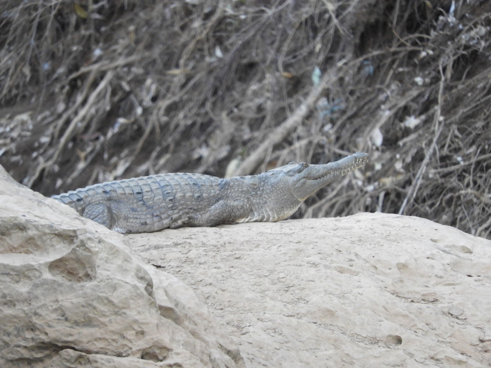 |
| Freshwater crocodile |
After lunch at Tunnel Creek and a rest back at camp, we walked into the battle site at Windjana Gorge for a sit by the waterside. It is a magnificent setting.
In the evening, Matthew went through the trip day by day to remind us what we had seen and done – an excellent idea. Presentations (organised by Sandie and Patti) to Matthew and Chris.
 |
| Queen Victoria, King Leopold Ranges |
Wednesday 28 June 2017. Day 63. Gibb Day 16. Windjana Gorge to Broome. Our final day on the Gibb Trip. Major clean up of our tents before handing them in. Called in at Derby for lunch. About 100km before Broome the rear tyre of the bus blew noisily after its battering on the Gibb.
 |
| Bell Gorge |
The 16 day Gibb River Broome to Broome Trip with Kimberley Safari Tours was excellent. Highly recommended. We had a very good time and enjoyed the company of the people on the trip a great deal. We will miss them as we all go our separate ways after our 16 day adventure together. (Matthew & Chris, Brenda & Michael, Patti & Ralph, Ruth & Georgina, Sandie & Lyn, Maureen & Rosemary, Jen & Rita, Lorraine, Burt.)
 |
| Matthew Bambach at Galvans Gorge |
At the beginning of the tour Matthew said that the reason he and his wife Carmel had set up Kimberley Safari Tours was to show people the places that they loved in the Kimberley. He certainly did that. He is an excellent guide and tour leader. His other objective is that we have fun while doing it. And we certainly did that. I’m not denying that there were a couple of trying hot days. However, we laughed our way around and had an excellent time. We certainly became used to the early (5:30am) starts – packed, in the bus and driving away by 7:10am.

Highlights: Without doubt the major highlights were Matthew, Chris and Kimberley Safari Tours; our fellow passengers who shared the adventures; the lady who drove the barges at Geikie Gorge; the lady who guided the Lake Argyle tour (which otherwise was a touch boring); Logan and Larissa of Ellenbrae Station; as for places – Rock Art; Echidna Chasm; Bell Gorge; Windjuna Gorge.