Kimberley Trip 2017 – week 11
We are on our way back.
 |
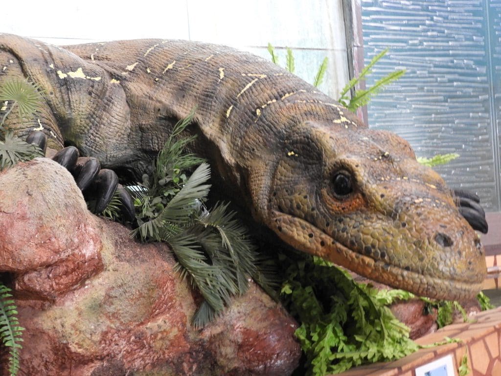
| Marsupial Lion with broken leg having fallen down a sink hole in the limestone |
Thursday 6 July 2017. Day 71. Drove 600km to Mount Isa. A huge day. Up early and away just before sunrise. Avery long drive across the Barkly Tableland – which is very flat and sometime treeless, but always uninteresting. Crossed into Queensland and escaped at last the very dangerous and mad NT drivers. Yes, we are delighted to leave NT. We are not alone. An NT newspaper, while headlining that Darwin is the fastest growing capital, included in the text that Darwin is haemorrhaging locals (especially women) who are leaving in droves to escape the drunken, roaring local males. We were planning to stay at Camooweal, but it was dry and hot and we thought that we would be cooler in the car and came onto Mount Isa – which has class 4 water restrictions and is dry and hot. However, it has Internet.
 |
| Diprotodont – a large fellow All of this skeleton was found The trunk is likely |
Friday 7 July 2017. Day 72. At Mount Isa. It rained off and on all day. The first rain since before we left Wagga 72 days ago. We did the guided tour at the Riversleigh Fossil Centre Museum at the Isa Outback Experience Centre. The Riversleigh tour was excellent. They are certainly finding many fossils and new animals at Riversleigh. Riversleigh is special for a number of reasons: the environment was very calcareous and anything the fell into water was covered with a layer of calcium and formed a fossil; many animals are preserved entire; the fossils are found in a limestone that is easily dissolved in weak acetic acid (vinegar); the limestone is soft, uncompressed and undeformed (so the fossils are not deformed either). A most remarkable site.
 |
| Crowded vanpark, Cloncurry |
Monday 10 July 2017. Day 75. Drove 120km to Cloncurry. We are at the Oasis vanpark in Cloncurry. A few years ago, when on another trip, I had rated the Cloncurry Oasis as my favourite vanpark. I could not rate it so now. Overused and become run down. We’ve noticed that over the last few years much bigger vans are on the road – most are now huge double axle jobs that were unusual just a few years ago. As a result, vanparks that were built for smaller vans cannot cope with the bigger vans which tend to make more mess, damage more grass, take much more space. More and more people are using the showers and washing machines in their vans – and discharging much more grey water that the park might not have been set up to handle. The big limbering vans, in their columns on the road, are a real traffic hazard.
 |
| Dazzle Ball? |
Tuesday 11 July 2017. Day 76. At Cloncurry. Spent the morning at the Museum/History Society talking with the historian about Cloncurry. My parents were married here in 1936. My father was a teacher here until 1941. My mother lived here from when she was almost 2 and her father was killed while clearing cyclone damage to the Burdekin Bridge between Ayr and Home Hill.
 |
| Early RFDS Medical Box Numbered containers. “Take numer 63” |
At that time, Cloncurry was a very large and important town: Royal Flying Doctors began here; QANTAS began here; School of the Air began here; Cloncurry was a major stopping place for aircraft flying from Europe to Brisbane/Sydney; largest stock saleyards in Australia; huge balls. My mother made her debut (who would hear of such a thing now) at a Dazzle Ball in August 1933 – presented to Lady Allardyce who had come up from Melbourne. Dazzle Balls were held yearly to raise money for the Church of England. This was a very important town. Today, Cloncurry is sliding towards a ghost town as its population decreases and houses disappear.
The Medical boxes (left) have increased from originally about 90 items to more than 300. All communication was done over the pedal wireless. The story I like is, “Sorry Doc. I did not have any 63s left, so I took two 25s and a 13. Was that ok? Over.”

Wednesday 12 July 2017. Day 77. Drove a stupidly long 528km from Cloncurry to Longreach. Long, long, long stretches of straight road across grassland. Between Cloncurry and Winton is Kynuna which is on the divide between Gulf country rivers and Eyre Basin rivers (Diamantina). A short stop at Winton for lunch. Winton claims (along with Richmond and Hughenden) to be the dinosaur capital of Australia. All three have good little dinosaur museums. Between Winton and Longreach, our old favourite acacias (gidgee and mulga) began to appear. We have not seen those since leaving Balranald all those days ago.
 |
| Brolga |
Thursday 13 July 2017. Day 78. We had brolgas around the van this morning. This van park is the largest that we have been in – ~300 vans. And demonstrates what I was talking about above. When the park was built, vans were smaller. Now, the huge vans find it hard to fit. As our neighbour banged on about for some time. Discharge of greywater from showers and washing machines was not an issue when the park was built. Now it is and huge mud bogs have formed in the park where vans run their grey water onto the bare dirt.

We went to see the Show at the Stockmans Hall of Fame this morning. It is excellent. The fellow who ran it did an excellent job of patter and showed a bit of working with animals in the deep north, including an explanation of why brahman cattle do so well up here. The dewlap under their neck gives them a built in cooling device and allows them to relish 40º+C days. This is the second time that we have seen the Show. Recommended, as is the Stockmans Hall of Fame itself – which is less about stockmen and more about white history of the outback.
Friday 14 July 2017. Day 79. Drove 421 km from Longreach to Emerald. Initially, we followed the busy Landsborough Highway to Barcaldine where we turned off along the Capricorn Highway. Quite a lot of kangaroo road-kill between Longreach and Barcaldine. The corvids are very fat and plentiful. The Capricorn Highway is winding and bumpy and crosses the Great Divide just east of Alpha and then the Belyando River (which flows into the Burdekin), then the Drummond Range before making its way past Rubyvale, Sapphire, Anakie to Emerald.
Saturday 15 July 2017. Day 80. Drove 350km from Emerald to Kinka Beach (Island View Caravan Park) where we intend to spend a few days. We have driven coast-to-coast, Broome (Indian Ocean) to Kinka Beach (Pacific Ocean). A long bloody way. The decision to come here was make to escape the heat (at the time) in the Kimberley. We wanted to be north of the Tropic (which we are) 23º13’S. Island View Caravan Park is my favourite for the trip. Second is Kimberly Land at Kununurra. Third G’day Mate at Alice Springs. This will be my last blog until we return to Wagga.